
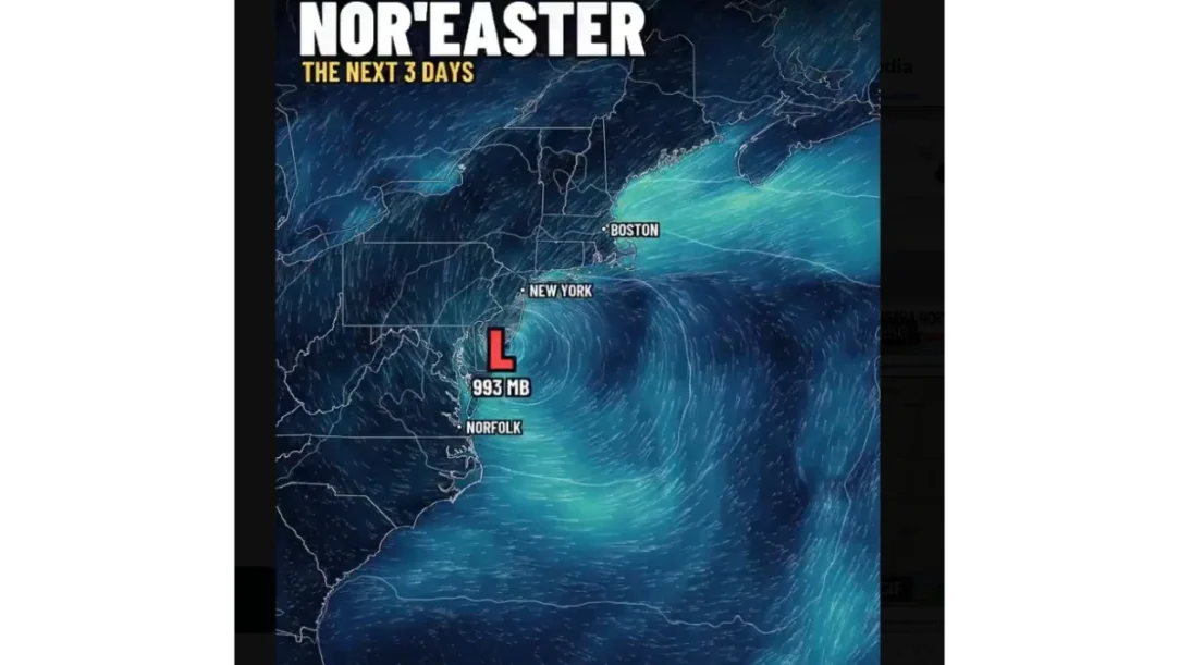
Watch the enclosed video of coastal New Jersey as floodwater covers roads and pushes into some homes. A nor’easter took shape Friday night into Saturday, September 26, 2026. We saw Surf City streets on Long Beach Island turn into wave-rippled channels. Our sources, including Associated Press reports, said tens of millions of people sit in the storm’s path.
Manasquan Mayor Mike Mangan warned of “a lot of water in the streets for a long time.” Sea Bright Mayor Brian Kelly said winds could hit 50 mph and floodwater could reach up to 6 feet on some streets, closer to an Irene-scale event than a routine tide flood.
This nor'easter doesn't want to leave.
It gets stronger off the Jersey shore tonight, and then on Sunday it turns around and comes right back.
If you live on the coast from the Outer Banks to Cape Cod, including New York City, watch the high tides this weekend.
Everyone else… pic.twitter.com/lAO0czts7C
— Ryan Hall, Y’all (@ryanhallyall) September 25, 2026
Watch the Atlantic City clip for boardwalk spray and street flooding on Melrose, Madison, and several lettered avenues. Depths ran from an inch or two to about 6 inches in spots Friday night. Ship Bottom roads went under. New Jersey and New York governors declared states of emergency. Manasquan issued a voluntary evacuation for low-lying blocks.
The National Weather Service flagged dangerous coastal flooding near New Jersey and Delaware, with more high-tide cycles through the weekend. A Surf City station logged a 74 mph gust. Offshore buoys reported waves of 16 feet or more.
Watch the enclosed New Jersey nor’easter flooding video here.
A massive nor'easter is hammering the East Coast, knocking out power to tens of thousands, disrupting hundreds of flights and threatening communities from the Mid-Atlantic into New England.
The Jersey Shore is already seeing some of the most dramatic impacts. Forecasters warn… pic.twitter.com/bZTu6wojnS
— Fox News (@FoxNews) September 26, 2026
Watch: New Jersey Roads Flood as Nor’easter Hits Homes
Kelly expected Saturday flooding to worsen by midday. Officials told drivers to stay out of floodwater and move cars off low streets before the next tide. Power outages were already in the thousands along the East Coast.
The storm is forecast to linger Sunday and weaken into Monday. Watch local emergency channels for road closures on Long Beach Island, the Atlantic City barrier, and Monmouth County shore towns. Rain of 2 to 4 inches is widespread, with local totals near 6 inches from New Jersey toward Boston.
Related posts:
 Urfi Javed Viral Video: ‘This Is How Everything Started’
 Watch: Aneet Padda’s Leaked ‘Shakti Shalini’ Video Goes Viral
 Rukmini Vasanth Deepfake Bikini Video Goes Viral, Threatens Legal Action
 Watch: TMC Goons Deface Modi’s Poster In Kolkata, Pavement Dweller’s Act Goes Viral in Video
 Manali Bikini Dance Video Sparks Backlash, Raises Questions on Decency
 Desmond Scott Caught Kissing a Mystery Woman at Houston Bar, Video Goes Viral
 100,000 Ordered to Evacuate in Washington – Rivers Swallow Homes Overnight
 Veterans Day Deals 2025: Free Meals Flood Restaurants As Big Chains Honor Service Members